|

Send
me Feedback!
 |
Brachina Gorge Geological Trail |
Brachina Gorge
Geological Trail
Brachina Gorge is located inside Flinders Ranges National Park between Wilpena and Blinman. You best start from the eastern end and make your way west through twenty kilometers which are usually accessible by conventional vehicle in good weather, though an offroad car generally brings better abilities and is recommended. Caping is possible in designated areas.
Quorn, Flinders Ranges
The gorge was first used as a commercial route for the transport of the copper ore from the mine in Blinman from 1862, until Blinman was connected with the northern railway through Parachilna Gorge in the 1880s.
The sedimental rocks along Brachina Gorge were deposited in a shallow and wide basin known as the Adelaide Geosyncline. They were transported by rivers and at times by glaciers and deposited on the seafloor between 650 and 500 million years ago. For much of this period, the area was flooded by the sea.
About 500 million years before our time, earthquakes and movements compressed the stonde to mountain ranges much higher than they are visible today. Big structures like the Wilpena Pound display the fierce forces of that time. Weathering and erosion reduced the height of the ranges by several kilometers and left what we can see today. When you cross Brachina Gorge, you can see a lot of exposed sediments that get younger the further west you come. There are red, brown and grey limestone, siltstone, quartzit and many fossils to be seen.
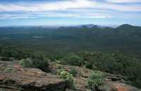
Wilpena Pound seen from St. Marys Peak, 1170 m
The region covers almost 150 million years of earth's history and is one of the best records of sedimentary evidence. Along with the fossils that are contained in the sediments, Brachina Gorge gives proof of the way life evolved during that time.