|
|
|

 Grampians National Park, Victoria
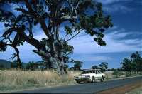
Driving up from the South Coast, you reach the Grampians National Park via Warnambool and Dunkeld. The Grampians are the most western parts of the Great Dividing Range and reach about 1000m ASL. Erosion and weathering of the rocks impressively show the age of the mountains, approximately 400 million years.
There are two routes to Halls Gap, the touristic centre of the Grampians, a direct one that is less impressive than the short detour on a small, winding road, parts of it not paved and which gives you a good impression of the region. After reaching Halls Gap we book a twin room in the recently opened, fully furnished and modern ECO Hostel. It's run by a friendly familiy that give you all the hints you need to explore the region and make you feel at home. There's a huge, open kitchen with all the things you normally miss in a hostel: Clean cutlery, enough space to store your food and facilites of quality. BTW take the chance to get a fresh egg every morning from their hens and pick your herbs from the garden with the instructions of the hosts.
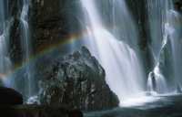
McKenzie Falls, on the road to Zumstein wildlife reserve and Wartook, are the best spot to pass the hot parts of the day and give you the possibility to cool down in the splashing waters. When you follow the steps down to the rock pool you really reach a great spot in the region and you won't be disappointed of the falls as they carry water throughout the year, fed by Wartook Reservoir and delivering freshwater to the northern region around Horsham. On the way back you come along Reed Lookout and the balconies which give you an impressive view over the south western slopes of the Grampians.
During noon, when temperatures may soar over 40°C, a visit of the Halls Gap Visitors Centre and the connected Brambuk Aboriginal Culture Centre of the Kooris is recommended. Both give you plenty of information of the region they call "Gariwerd", display beautiful paintings and traditional culture. Internet is really cheap (4$/h) and for the same prize you may enter the Gariwerd Dreaming Theatre with a Multimediashow about traditional history and culture.
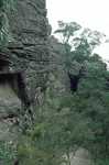
After a thunderstorm during the night, temperatures are more comfortable the next day and we decide to climb the Pinnacles. We start from the appropriate car park and enter the Wonderland Range with its carved and eroded scenery. Only a few minutes after leaving the road you reach Grand Canyon hinein, formed by periodically running water. The Canyon is about 30 to 50m deep and like a genuine canyon winding into the mountains. On certain parts there are artificial steps and aids to make the access more easy as the path can get slippery and pretty dangerous when wet. Afte the first effort you reach Silent Street through a forest of Gum Trees, another canyon with narrow areas, only 1m wide. In the end you reach the top, the Pinnacles, 686 m ASL offering you a spectacular view over Halls Gap and the region with its lakes and dams. As always, there's no railing or banister, so be careful when approaching the edge of the rocks, on of them called the nerve test.
There is a lot of rock painting in the park, but most of them are not accessible for the public. Most guides and the visitors centre recommend the following four: In the northern area of the Grampians near Mt. Stapylton: Gulgurn Manja Shelter and Ngamadjidj Shelter and in the western Grampians Billlimina und Manja Shelter close to the Buandik campsites.